
Assam Flood 2026 : Monsoon Death Toll Crosses 50 - What We Know So Far
A clear look at the rising toll, worst-hit districts, rescue gaps and the causes behind the Assam Flood 2026 crisis
 IN
Thu, Oct 22, 2026 | 02:17 AM IST
IN
Thu, Oct 22, 2026 | 02:17 AM IST


Whole villages in Upper Assam went under water within hours. Families climbed onto rooftops, roads became rivers and rescue teams struggled to enter settlements that even boats could not reach.
The crisis matters beyond the immediate casualties. It has hit communities with little recent experience of flooding at this scale, raising questions about upstream rainfall monitoring, early warnings and whether rescue resources were positioned in time. Ground reports described unusually rapid flooding across inland parts of Sivasagar, Charaideo and Jorhat.
The Times of India reported that the overall monsoon-season toll had crossed 50 by July 22. A later update based on Assam State Disaster Management Authority data placed the confirmed 2026 toll at 41 after 10 deaths were recorded in one day. Different cut-off times explain why the Assam flood death toll varies across reports.
| Category | Reported figure |
| Overall monsoon-season toll reported by TOI | More than 50 |
| Confirmed 2026 flood toll in later ASDMA update | 41 |
| People affected | More than 6.53 lakh |
| Districts affected | 11 |
| Villages inundated | 939 |
| Agricultural land affected | 24,897.27 hectares |
| People rescued | More than 8,500 |
| Shelters and relief distribution centres | 487 |
| People feared missing, according to the chief minister | Around 100 |
These numbers came from reports issued at different times on July 22 and July 23. They may change as district teams reach cut-off settlements and verify missing-person reports.
One report counted deaths across the full monsoon season. Another counted confirmed flood deaths during 2026, while earlier updates focused on one particularly deadly 24-hour period.
Missing residents are not added to the official toll until authorities confirm what happened.
Himanta Biswa Sarma said around 100 people were feared missing, mainly in Sivasagar, and warned that the number of deaths could rise. The figure was an estimate based on reports reaching the government, not a final verified missing-person count.
This distinction is important. A headline number can quickly become outdated when roads, phone networks and entire villages remain inaccessible.
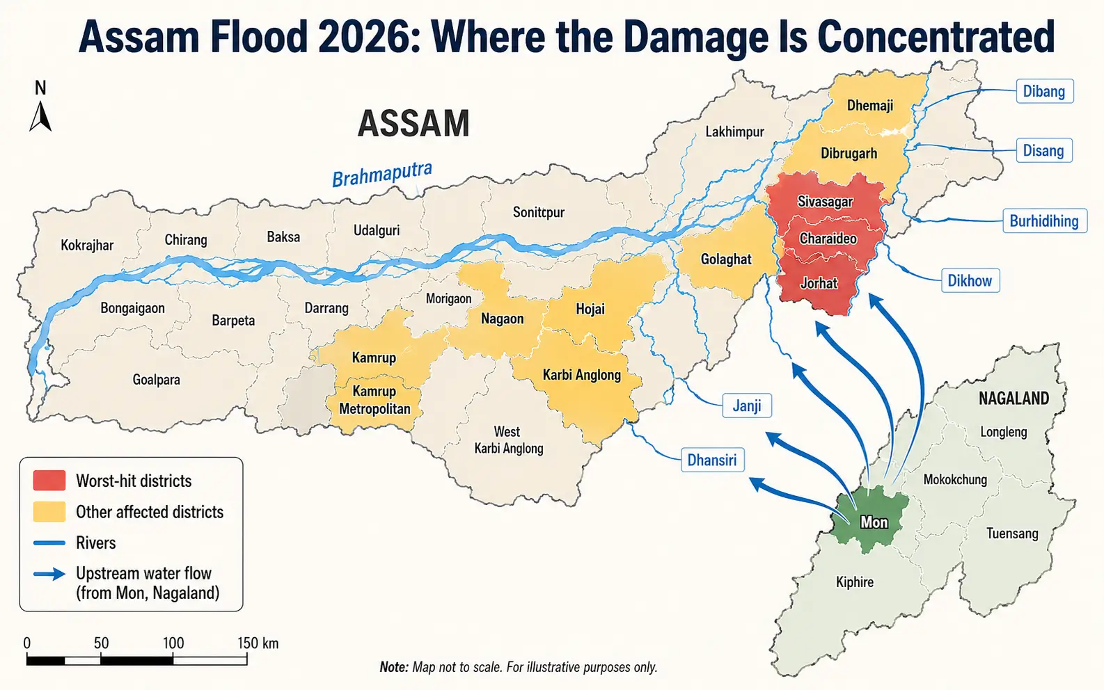
Sivasagar has reported the largest affected population, with nearly four lakh people impacted. Charaideo had around 1.11 lakh affected residents, while more than 97,000 people were facing flooding in Jorhat.
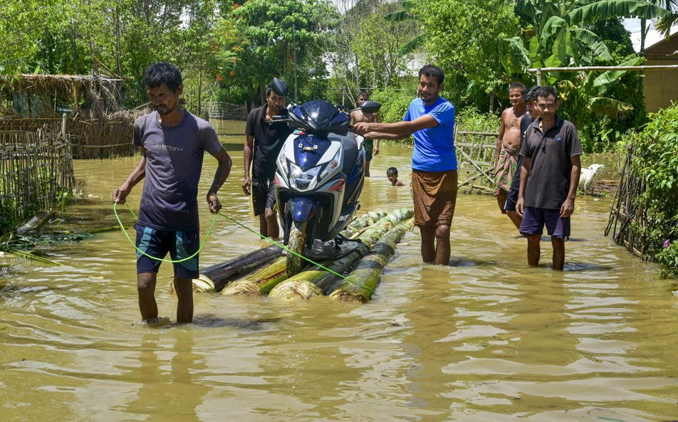
Ground reports described families waking to fast-rising water and moving onto rooftops, raised roads or furniture before rescue boats arrived.
This Assam flood has been especially destructive because water entered inland communities that do not usually experience flooding of this magnitude. The Dikhow, Disang and Janji tributaries swelled rapidly and spread water across large parts of Upper Assam.
More than 900 villages were under water in the July 23 assessment. Nearly 24,900 hectares of farmland were affected, putting crops and rural incomes at risk. The final losses will only become clear after water levels fall and field surveys begin.
The Assam government linked the sudden surge to intense rainfall in upstream parts of Nagaland and Arunachal Pradesh. Himanta Biswa Sarma described the Nagaland event as a cloudburst and said the resulting water discharge entered Upper Assam.
However, the use of the word “cloudburst” remains disputed.
A scientist at the Meteorological Centre in Kohima told The Indian Express that Nagaland’s Mon district recorded 137 mm of rain over eight to nine hours. The rain was exceptionally heavy, but it did not meet the India Meteorological Department’s technical cloudburst threshold of more than 100 mm within one hour.
The scientist said earlier spells of heavy rainfall had already saturated the hills. The fresh downpour then produced rapid runoff into rivers flowing towards Assam.
Satellite images and a detailed hydrological study will be needed before the upstream rainfall can be treated as the only confirmed cause.
The Army, Indian Air Force, NDRF, SDRF, Assam Police, Fire and Emergency Services and district teams have been conducting evacuations.
The Army deployed specialised flood-relief columns under Operation Jal Rahat. Helicopters were used to carry supplies, while drones helped authorities assess areas that could not be reached by boat. More than 8,500 people had been rescued from affected districts in the later ASDMA update.
The Assam flood relief operation has also faced serious access problems. The chief minister acknowledged that authorities had not reached every village because roads had disappeared and some areas remained beyond the reach of boats.
Residents in isolated areas reported delays in receiving food, medicines and safe drinking water.
Img Src : NDTV
The administration was operating 487 shelters and relief distribution centres across 10 districts, supporting 24,418 people.
The two types of facilities should not be confused. Shelters house displaced families, while distribution centres supply food and essentials to residents who may still be staying near their homes.
The state government announced compensation of ₹4 lakh for the next of kin of each person who died. It also promised to help families replace identity papers and other documents lost in the water.
The next stage of Assam flood relief must prioritise clean water, sanitation, basic medicines, infant food and support for older or immobile residents. These needs will continue as families begin returning to damaged homes.
TUI’s earlier explainer on disaster management in India explains why early warnings, communication networks and pre-positioned supplies are central to an effective emergency response.
Floodwater entered the Simaluguri station yard and railway colony after the Dikhow River overflowed. Water also overtopped nearby tracks.
Northeast Frontier Railway suspended operations on the Simaluguri–Namtiali and Simaluguri–Selenghat sections. Long-distance trains were diverted, while several local services were cancelled or short-terminated.
Roads, bridges and embankments were also damaged or submerged. These disruptions can slow the movement of food, fuel, medicines and rescue equipment into the worst-hit districts.
The flooding follows other major monsoon disruptions across India. TUI recently examined why extensive preparations failed to prevent repeated waterlogging during the Mumbai rains crisis.
The IMD warning issued on July 23 forecasts very heavy rainfall, thunderstorms and lightning over Assam and Meghalaya. Heavy rainfall warnings continued through July 29.
Rivers can remain high even after local rain eases because water from upstream areas may continue moving downstream.
The Assam flood death toll may change again as teams verify reports from villages that were inaccessible. But rescue is only the first part of the response.
At this difficult time, we must come together as citizens and support the families affected by the Assam floods. Every contribution—whether food, medicines, shelter or verified information - can make a real difference. TheUnitedIndian also urges the state and central governments to take every necessary measure to speed up rescue work, ensure relief reaches isolated villages and provide timely compensation and long-term rehabilitation to affected communities.
Everything you need to know
The Times of India reported that Assam’s overall monsoon-season death toll had crossed 50. A later ASDMA-linked update placed the confirmed 2026 flood toll at 41. The difference reflects separate reporting periods and cut-off times.
More than 6.53 lakh people across 11 districts were affected in the later ASDMA assessment. Sivasagar, Charaideo and Jorhat were among the worst-hit districts.
The Assam government linked the sudden flooding to intense upstream rainfall in Nagaland and Arunachal Pradesh. Saturated hill catchments and rapidly rising tributaries also contributed to the spread of water.
The Army, Indian Air Force, NDRF, SDRF, Assam Police, Fire and Emergency Services and district authorities are involved in evacuations, relief distribution and medical support.
The Brahmaputra and tributaries including the Dikhow, Disang, Burhidihing and Dhansiri were reported above danger or severe-flood levels at different monitoring points.




Oct 19, 2026
TUI Staff
Oct 19, 2026
TUI Staff
Oct 17, 2026
TUI Staff
Oct 17, 2026
TUI Staff
Oct 19, 2026
TUI Staff
Oct 19, 2026
TUI Staff
Oct 17, 2026
TUI Staff
Oct 17, 2026
TUI Staff

Stay informed with independent, fact-checked journalism on technology, environment, government, economy and more. India’s most trusted digital news platform.






Comments (0)
Be the first to comment!